| .
|
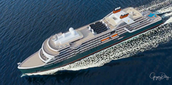
14-Day Legend Of The Icelandic Sagas
on the Expedition Ship Seabourn Venture
July, 2023
-
The photos, videos, stories and background information of this expedition are written in journal form, that is, day by day.
Below is a Table of Contents which links to each day of the expedition for easy access or, if you prefer, you can simply scroll down and read the adventures of the entire expedition day by day.
The left hand column contains links to my photos stored in my Adobe Portfolio and links to my videos stored in my YouTube channel.
- June 29 - Lafayette, LA to Reykjavik, Iceland
- June 30 - Arrive Reykjavik
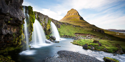
- July 1 - Exploring the Golden Circle, Waterfalls, Geysers and more
- July 2 - Embark the Expedition Ship Seabourn Venture
- July 3 - Grundarfjordur, Iceland, Famous Mountain
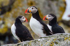
- July 4 - Vigur, Iceland, Puffin Home
- July 5 - Húsavík, Iceland, Whale Museum
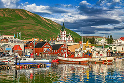
- July 6 - Seydisfjordur, Iceland, Colorful Sidewalk
- July 7 - Djupivogur and Papey Island, Iceland
- July 8 - Heimaey, Vestmannaeyjar, Iceland, Volcano Survival
- July 9 - Denmark Strait, en route to Prins Christian Sund, Greenland
- July 10 - Prins Christian Sund, Greenland, Zodiac Exploration
- July 11 - Hvalsey and Uunartoq, Greenland, Viking Church
- July 12 - Aappilattoq & Kangerluq Fjord, Greenland, SUBMERSIBLE Dive
- July 13 - East Greenland Polar Plunge
- July 14 - Greenland Sea, Greenland, Polar Bear Hunt
- July 15 - Denmark Strait to Reykjavik, Iceland, Tour of Ship's Bridge
- July 16 - Disembark, Reykjavik, Iceland, Litli Hrútur Volcano
- July 17 - The LONG, Ridiculous Flight Home
|
Stock Photos, En Route Journey
|
-
Thursday, 6/29/23, and I'm off to the Seabourn 14-Day Legend Of The Icelandic Sagas
-
Kali arrives LVCC (Lafayette Veterinary Care Center) for 18 days boarding with four hours of play each day with her friends. Thankfully she loves it there.
-
Arrive Lafayette Airport at 9am, my usual two hours early for international flights. Depart on Delta 3598 commuter jet at 11:00 am to Atlanta. Arrive Atlanta 1:45 pm (1 hour time change.)
-
There is a two hour layover in Atlanta and then depart Atlanta at 3:41 pm on Delta 2023 to New York JFK airport. Arrived JFK at 6:20 pm. The five hour layover passes nicely in the Delta Sky Lounge. Depart JFK at 11:15 pm and arrive Reykjavik the next day (6/30) at 9:05 am.
-
Delta managed to fly on time for all three flight segments. I arrived at the Keflavik Airport (near Reykjavik) exhausted, but on time.
- Return to Table of Contents
|
Stock Photos, Reykjavik, Iceland
|
- Fridya, 6/30/23, Arrived Reykjavik one day early
- Arrived in Reykjavik at 9:05 am. Seabourn's private transfer driver failed to meet me after half an hour of waiting. The owner of the local taxi company hooked me up with one of his drivers, Johann Armannson, who drove me to my hotel, the Radisson Blu 1919 Htel in Reykjavik. Slept for quite a whiule. Had a really excellent meal at the Apothetek Restaurant. I highlty recommend it.
-
Iceland is a Nordic Island country in the North Atlantic Ocean and in the Arctic Ocean. Iceland is the most sparsely populated country in Europe. Iceland's capital and largest city is Reykjavík, which (along with its surrounding areas) is home to over 65% of the population. Iceland is the biggest part of the Mid-Atlantic Ridge that rises above sea level, and its central volcanic plateau is erupting almost constantly. The interior consists of a plateau characterized by sand and lava fields, mountains, and glaciers, and many glacial rivers flow to the sea through the lowlands. Iceland is warmed by the Gulf Stream and has a temperate climate, despite a high latitude just outside the Arctic Circle. Its high latitude and marine influence keep summers chilly, and most of its islands have a polar climate.
-
According to the ancient manuscript Landnámabók, the settlement of Iceland began in 874 AD when the Norwegian chieftain Ingólfr Arnarson became the first permanent settler on the island. In the following centuries, Norwegians, and to a lesser extent other Scandinavians, emigrated to Iceland, bringing with them slaves or serfs of Gaelic origin.
-
The island was governed as an independent commonwealth under the native parliament, the Althing, one of the world's oldest functioning legislative assemblies. Following a period of civil strife, Iceland acceded to Norwegian rule in the 13th century. The establishment of the Kalmar Union in 1397 united the kingdoms of Norway, Denmark, and Sweden. Iceland thus followed Norway's integration into that union, coming under Danish rule after Sweden seceded from the union in 1523. The Danish kingdom forcefully introduced Lutheranism to Iceland in 1550.
-
In the wake of the French Revolution and the Napoleonic Wars, Iceland's struggle for independence took form and culminated in independence in 1918 with the establishment of the Kingdom of Iceland, sharing through a personal union the incumbent monarch of Denmark. During the occupation of Denmark in World War II, Iceland voted overwhelmingly to become a republic in 1944, thus ending the remaining formal ties with Denmark. Although the Althing was suspended from 1799 to 1845, the island republic has been credited with sustaining the world's oldest and longest-running parliament.
-
Until the 20th century, Iceland relied largely on subsistence fishing and agriculture. Industrialization of the fisheries and Marshall Plan aid following World War II brought prosperity, and Iceland became one of the wealthiest and most developed nations in the world. It became a part of the European Economic Area in 1994; this further diversified the economy into sectors such as finance, biotechnology, and manufacturing.
-
Iceland has a market economy with relatively low taxes, compared to other OECD countries, as well as the highest trade union membership in the world. It maintains a Nordic social welfare system that provides universal health care and tertiary education for its citizens. Iceland ranks high in democracy and equality indexes, ranking third in the world by median wealth per adult. In 2020, it was ranked as the fourth-most developed country in the world by the United Nations' Human Development Index, and it ranks first on the Global Peace Index. Iceland runs almost completely on renewable energy.
-
Icelandic culture is founded upon the nation's Scandinavian heritage. Most Icelanders are descendants of Norse and Gaelic settlers. Icelandic, a North Germanic language, is descended from Old West Norse and is closely related to Faroese. The country's cultural heritage includes traditional Icelandic cuisine, Icelandic literature, and medieval sagas. Iceland has the smallest population of any NATO member and is the only one with no standing army, with a lightly armed coast guard.
- Return to Table of Contents
|
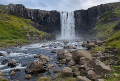
My Photos, The Golden Circle
Near Reykjavik, Iceland
|
-
Saturday, 7/1/23, Reykjavik and the Golden Circle
-
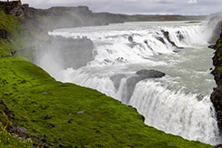
Hired my taxi driver from yesterday, Johann Armannson, to give me a 6 hour tour of the Golden Circle. It was fascinating. I saw Geysers, Waterfalls, Farms, Geothermal Springs, Geothermal Electrical Plants, Volcano Craters and much more.
-
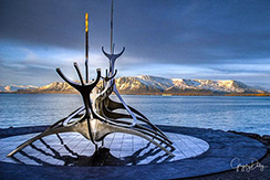
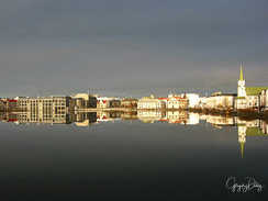
Reykjavík is the capital and largest city of Iceland. It is located in southwestern Iceland, on the southern shore of Faxaflói bay. Its latitude is 64°08' N, making it the world's northernmost capital of a sovereign state. With a population of around 131,136 it is the center of Iceland's cultural, economic, and governmental activity, and is a popular tourist destination.
-
According to legend, the first permanent Norse settlement in Iceland was established at Reykjavík by Ingólfr Arnarson around the year AD 870, as described in the Book of Settlement.
-
Ingólfr is said to have decided the location of his settlement using a traditional Norse method: when land was in sight, he cast his high seat pillars overboard and promised to settle where the gods decided to bring them ashore. Two of his slaves then searched the coast for three years before finding the pillars in the bay which eventually became the site of Reykjavík.
-
The name is of Old Norse origin, derived from the roots reykr ('smoke') and vík ('bay'). The name is said to be inspired by steam rising from hot springs in the region. The name has been translated as Bay of Smoke in English language travel guides, or variations thereof, such as Smoky Bay, Smoke Cove, Steam Bay, etc.
-
Reykjavík has a subpolar oceanic climate closely bordering on a continental subarctic climate in the 32°F isotherm. At 64° North, Reykjavik is characterized by extremes of day and night length over the course of the year. From 20 May to 24 July, daylight is essentially permanent as the sun never gets more than 5° below the horizon. Day length drops to less than five hours between 2 December and 10 January. The sun climbs just 3° above the horizon during this time. However, day length begins increasing rapidly during January and by month's end there are seven hours of daylight.
-
Despite its northern latitude, temperatures very rarely drop below 5 °F in the winter. The proximity to the Arctic Circle and the strong influence of the North Atlantic Current, an extension of the Gulf Stream shape a relatively mild winter and cool summer. The city's coastal location does make it prone to wind, however, and gales are common in winter (influence of the Icelandic Low). Summers are cool, with temperatures fluctuating between 50 and 59 °F, rarely exceeding 68 °F. This is a result of exposure to the maritime winds in its exposed west coast location that causes it to be much cooler in summer than similar latitudes in mainland Scandinavia.
-
Contrasting this, winter days are milder than anywhere in far southern Sweden and the vast majority of Denmark. Reykjavík averages 147 days of rain (more than 1 mm) per year. Droughts are uncommon, although they occur in some summers. July and August are the warmest months of the year on average and January and February the coldest.
-
In the summer of 2007, no rain was measured for one month. Summer tends to be the sunniest season, although May averages the most sunshine of any individual month. Overall, the city receives around 1,300 annual hours of sunshine, which is comparable with other places in northern and north-western Europe such as Ireland and Scotland, but substantially less than equally northern regions with a more continental climate, including the Bothnian Bay basin in Scandinavia.
-
Nonetheless, Reykjavík is one of the cloudiest and coolest capitals of any nation in the world. The highest temperature recorded in Reykjavík was 78 °F, reported on 30 July 2008, while the lowest-ever recorded temperature was −12 °F, recorded on 21 January 1918. The coldest month on record is January 1918, with a mean temperature of 19 °F. The warmest is July 2019, with a mean temperature of 56 °F.
-
MAIN SITES
▪ Alþingishúsið – the Icelandic parliament building.
▪ Austurvöllur – a park in central Reykjavík surrounded by restaurants and bars
▪ Árbæjarsafn (Reykjavík Open Air Museum) – Reykjavík's Municipal Museum
▪ CIA.IS – Center for Icelandic Art – general information on Icelandic visual art
▪ Hallgrímskirkja – the largest church in Iceland
▪ Harpal Reykjavík – Reykjavík Concert and Conference Center
▪ Heiðmörk – the largest forest and nature reserve in the area
▪ Höfði – the house in which Gorbachev and Reagan met in 1986 for the Iceland Summit
▪ Kringlan – the second-largest shopping mall in Iceland
▪ Laugardalslaug – swimming pool
▪ Laugavegur – main shopping street
▪ National and University Library of Iceland (Þjóðarbókhlaðan)
▪ National Museum of Iceland (Þjóðminjasafnið)
▪ Nauthólsvík – a geothermally-heated beach
▪ Perlan – a glass dome resting on six water tanks
▪ Reykjavík Town Hall – city hall
▪ Rauðhólar – a cluster of red pseudo- craters
▪ Reykjavík 871±2 – exhibition of an archaeological excavation of a Viking-age longhouse, from about AD 930
▪ Reykjavik Art Museum – the largest visual art institution in Iceland
▪ Reykjavík Botanic Garden
▪ Reykjavík Maritime Museum – a maritime museum by the old harbour
▪ Safnahúsið, culture house, National Centre for Cultural Heritage (Þjóðmenningarhúsið)
▪ Tjörnin – a small lake in central Reykjavík
▪ University of Iceland
- Return to Table of Contents
|
My Photos, Boarding the Seabourn
Venture and Departing Reyhjavik
Stock Video, Submarine Experience
(1 Minute)
Stock Video, Submarine Experience
(16 Minutes)
Stock Video, Touring the Ship
(23 Minutes)
|
-
Sunday, 7/2/23, Embark the Expedition Ship Seabourn Venture and Depart Reykjavik, Iceland
-
The transfer from the hotel to the ship went off without a hitch. My two Pelican cases, backpack and myself made it to the ship without incident. Went through the usual security checks and was issued my ID card/room key. They have all of this down to such a science. Found a Large instead of 2XL parka in my room. Went through the exchange process. I really like the parkas, they are light weight and waterproof. Then there is an extra inside layer if you need more warmth. You can't miss them in the photos. They are an off-yellow Helly Hansen expedition gear product.
-
Went through the safety training and briefings. Had a wonderful meal in the Restaurant. The food is really great here. Early bed to be ready for a busy day tomorrow. Smooth sailing during the evening.
-
The Arctic Circle marks the southernmost latitude at which, on the December solstice, the shortest day of the year in the northern hemisphere, the sun will not rise all day, and on the June solstice, the longest day of the year in the northern hemisphere, the sun will not set. These phenomena are referred to as polar night and midnight sun respectively, and the further north one progresses, the more pronounced these effects become. For example, in the Russian port city of Murmansk, just 3° above the Arctic Circle, the sun does not rise for 40 successive days in midwinter.
-
The position of the Arctic Circle is not fixed and currently runs 66°33′49.3″ north of the Equator. Its latitude depends on the Earth's axial tilt, which fluctuates within a margin of more than 2° over a 41,000-year period, owing to tidal forces resulting from the orbit of the Moon.
-
Consequently, the Arctic Circle is currently drifting northwards at a speed of about 48 ft per year.
- Return to Table of Contents
|
My Photos, Grundarfjordur
& Snaefellsnes Peninsula
|
-
Monday, 7/3/23, Grundarfjordur, Iceland
-
Grundarfjörður is a town in the north of the Snæfellsnes peninsula in the west of Iceland. It is situated between towering mountains and crystal clear waters. One of the main attractions in Grundarfjordur is the majestic Kirkjufell Mountain which towers over the town and is considered one of the most photographed mountains in Iceland.
-
Some of us (not me) climbed the majestic Kirkjufell Mountain. Most of us did an all day bus tour of the Snaefellsnes National Park and saw towering glaciers, stunning fjords, and an abundance of wildlife, seals and seabirds. We visited one of the many black beaches created by cooled, crushed volcanic lava.
-
The town received the right to do commerce in 1786. Around 1800, French merchants came to Iceland and lived in Grundarfjörður, where they constructed a church and a hospital of their own. The town became wealthy through the fishing industry, and this wealth is shown in the style of the original, luxurious houses being built. The road to nearby Stykkishólmur crosses a lava field called Berserkjahraun. The name of the lava field comes from the Eyrbyggja saga, according to which two Berserkers were slain here by their master, because one of them fell in love with his master's daughter.
|
My Photos, Vigur, Iceland
|
-
Tuesday, 7/4/23, Vigur, Iceland
-
Vigur, a privately owned island, is the second largest island of the Ísafjarðardjúp fjord in Westfjords, Iceland. It is a place where time seems to stand still. The family that owns the island bases its livelihood mainly on tourism along with the collection of eggs and eiderdown. The island is home to thousands of birds - eider ducks, eider terns, puffins and more.
-
The plan was to take zodiacs ashore and see an abundance of birds in their natural habitats. However, the weather did not cooperate. The wind made zodiac operations a bit risky and the rain made the whole thing a bit chilly. The zodiac shore trips were cancelled.
-
Located just south of the Arctic Circle, the island is around 6,600 ft in length and 1,300 ft in width. The island is most noted for its thriving seabird colonies—particularly Atlantic puffins —traditional eiderdown production and historical buildings.
-
The two story Viktoriuhús, built in 1860, is one of the oldest timber buildings in Iceland and is part of The Historical Buildings Collection of Þjóðminjasafn Islands. Iceland's oldest seaworthy boat, Vigurbreiður, is also on Vigur.
-
Today, there is only a single farm located on Vigur. In the seventeenth century the farm on Vigur was home to Magnús Jónsson, a wealthy man who collected and commissioned manuscripts. The first reference to Vigur in the written record is 1194 but it may well be referenced earlier than that under a different name.
-
A windmill, built in c. 1840, is also located on the island. It is the only surviving historic windmill in the country and possibly the northernmost windmill in the world.
-
Each year around 3,500 nests of the Common Eider are found on Vigur. The nests are lined with Eider Down which is collected by the farmer once eggs have hatched and chicks vacated. The Eider Down is dried, sorted and cleaned by hand using methods passed down through generations.
-
Vigur is home to one of the largest puffin colonies in Iceland as well as a rare colony of Black Guillemot. It also hosts vast numbers of Arctic Tern and other Arctic seabirds.
- Return to Table of Contents
|
MY Photos, Húsavík, Iceland
|
-
Wednesday Morning, 7/5/23, Húsavík, Iceland
-
Latitude: 66.04° Longitude: -17.36°
-
Húsavík is a beautiful town of 2,500 people in Northeast Iceland. This is where the Viking Garðar Svavarsson made the first ever overwinter stay in Iceland around the year 965 AD. Today, Húsavík is best known for whale-watching in Skjálfandaflói Bay where there is an abundance of humpback whales and occasional sightings of blue whales.
-
Húsavík greeted Seabourn Venture with a cold breeze from the north and rain. This did not stop many of us from walking to the highly interesting whale museum, that has a good collection of exhibits, including a full skeleton of a blue whale. The unique GeoSea thermal baths in town also got many visits. Tours out of town were also popular, particularly a drive to Goðafoss waterfall and Lake Mývatn.
-
Mývatn boasts a high population of nesting waterfowl and wetland birds, including Harlequin Duck and many others. Mývatn is also known for its lava fields, home to spectacular lava formations such as the Dimmuborgir lava castles. There are also geothermal areas around Mývatn, and it was a special treat to stop at Námaskarð to enjoy the stream and mud springs.
-
Meanwhile, a tour to the National Park in Ásbyrgi was also offered. Ásbyrgi is a canyon with a beautiful horseshoe-shaped cliff formation and is considered one of the natural wonders of Iceland. According to legend, Ásbyrgi was formed when Sleipnir, the horse of heathen God Odin, stepped on the lava. The more scientific explanation is that the Ásbyrgi canyon was formed during two huge floods that happened some 8,000 and 3.000 years ago.
- Return to Table of Contents
|
My Photos, Seydisfjordur, Iceland
|
-
Thursday, 7/6/23, Seydisfjordur, Iceland
-
Latitude: 65.26° Longitude: -14.00°
-
What is it about Iceland? Perched betwixt two continental plates, geologically complex and, above all, scenically bewitching, it consists of a succession of vistas that makes one want to break into spontaneous applause.
-
This morning, we were treated to yet another topographical encore. The ship arrived at Seyðisfjörður, a narrow, twisting fissure that extends deep into eastern Iceland. The low cloud and drizzle of the previous day had passed, and fair conditions prevailed. As the ship docked at the small town of the same name, everyone was champing at the bit for a chance to debark and explore.
-
Three alternative shore excursions were offered. One was a guided walk around town. Colourful clapboard houses were scattered about a small anabranch of the main fjord. Many had been decorated as befitting the whim of their owners - this being a recognised hot spot within the Icelandic arts community. The most obvious public artwork was the rainbow path leading to the church.
-
Other attractions were just a short ride away. Some guests visited one of Europe's pioneer organic agriculture enterprises. The Nordic climate is not conducive to the growth of many Mediterranean vegetables and grains. Yet, this farm - one of the northernmost in the world where grain is grown - is leading the way in organic agriculture. Hot water is everywhere in this country, and after visiting the farm, we could take full advantage of a restorative soak at the thermal spa pools at nearby Vök.
-
The third and most popular option was a visit to the Skálanes nature reserve. This private research centre aims to encourage investigation into and preservation of Iceland's natural environment and cultural legacy. De-stocked ex-farmland and revegetation work to restore some of the country's lost forests serve as a model for future land use and sustainable tourism. Most importantly, there were also Atlantic Puffins!
-
The remote town of Seydisfjördur is perched at the end of a narrow twisting fjord in East Iceland. A very picturesque village of 700 people, it is known for its thriving arts scene and large number of resident artists. Tourism is on the rise as well, as its natural setting of mountains and waterfalls is simply breathtaking. Surrounded by impressive 3,560-foot-tall snow-capped mountains, Seydisfjördur is home to the Technical Museum of Iceland. It was settled by Norwegian fishermen in 1848 and quickly became an important trading center between Iceland and Europe. It is known throughout Iceland for its colorful Norwegian-style wooden houses..
-
A road over Fjarðarheiði mountain pass (elevation 2,000 ft) connects Seyðisfjörður to the rest of Iceland. Seyðisfjörður is surrounded by mountains with the most prominent Mt. Bjólfur to the west (1085 m) and Strandartindur (1010 m) to the east. The fjord itself is accessible on each side from the town, by following the main road that leads through the town. Further out the fjord is fairly remote but rich with natural interests including puffin colonies and ruins of former activity such as nearby Vestdalseyri from where the local church was transported.
-
There are several waterfalls in the town. A popular hiking path starts at the town center, following the East bank of the Fjarðará, the river that flows through the center of town. Further up the river there are 25 waterfalls. During the winter, a skiing area is used in Fjarðarheiði mountain pass.
-
The first telegraph cable connecting Iceland to Europe made landfall here in 1906. A large dam was constructed here in 1913, which produced power for the country’s first high voltage AC power plant, a revolutionary achievement for its time.
- Return to Table of Contents
|
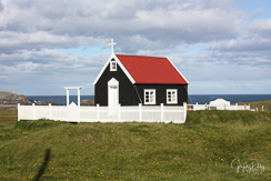
My Photos, Djupivogur and Papey Island, Iceland
|
-
Friday, 7/7/23, Djupivogur and Papey Island
-
Latitude: 64.28° Longitude: -14.58°
-
It was like sailing into the deep misty mountains of Jurassic Park this morning as Seabourn Venture made its way to Djupivogur. On arrival, the coastline was shrouded in mist as some of us headed ashore for some wonderful hikes and to explore the famed rock museum. The clouds cleared throughout the morning, and the blue sky appeared in greeting. Several walks were offered, long and short, all with fantastic views of the wonderful surrounding nature. Birds were out in their droves, from the elegant Arctic Tern to the gorgeous Black-tailed Godwit, to the plentiful Common Eiders with cute little fluffy ducklings trailing behind them.
-
Independent adventurers could explore the small fishing village and visit its unique rock museum, home to many spectacular rock formations of every shape, size, and colour. A short walk away, there were a few independent shops, including one filled with whale bones, baleen, and reindeer antler. Further down the road, one could visit the beautiful egg sculptures, each depicting the egg of one of 30 different bird species. Made of locally-sourced stone, these were quite spectacular.
-
After having lunch back onboard, Seabourn Venture sailed next to Papey Island. Papey is very exposed to the elements, and the wind and swell on arrival did not favour expedition operations. The planned Zodiac cruise, unfortunately, had to be cancelled. However, using Seabourn Venture's excellent GSS camera, we were able to have wonderful views of the island, its bird colonies, and the unique geological features of its cliffs. The images from the GGS camera were broadcast live in the Discovery Centre, accompanied by live commentary from the Expedition Staff - Jon Sigurdsson, Kini Roesler and Tess Hudson - who animatedly explained the island's geology, history, birdlife, marine life and other wildlife. Guests learned a lot about the perfect little Atlantic Puffins, the cool Black-legged Kittiwakes and why seals occasionally lie in a banana shape while on land. All the while looking at the remarkable animals live on screen.
-
Later in the afternoon, we listened to an intriguing lecture about the 'Marine Mammals of Iceland' by Tess Hudson. In this, they learned how to disentangle humpback whales, how the killer whale got its name and why marine mammals are drawn to Icelandic waters. Later in the evening, the daily Recap and Briefing allowed everyone a glimpse into the exciting possibilities of the following day, and an evening conversation with Heidi, the astronaut, had us all thinking about space travel and beyond.
-
Papey, Celtic for ‘Friar’s’ Island, is situated 3 miles off of the eastern coast of Iceland. Although the largest island in Eastern Iceland, it is only 0.77 sq mi in area. Its windswept, grassy slopes rise to 190 feet culminating in a rock formation called the Castle. Rocky sea cliffs surround much of the island, providing excellent habitat for nesting sea birds. Guillemots occupy Papey until mid-summer while Atlantic puffins abound until mid-September. Seals and eider ducks can be found here during breeding season.
-
Although there is evidence of early Norse settlement, the island takes its name from Irish monks known as ‘papar’ who presumably occupied the island. The medieval Icelandic ‘Book of Settlements’ mentions this as a place inhabited by these ‘Vestmen’ (men of the west).
-
Today, a lighthouse, a dwelling and a church are on the island. The small church, with its white picket fence and red roof is the oldest wooden church in Iceland, built in 1902.
- Return to Table of Contents
|
My Photos, Heimaey, Vestmannaeyjar
|
-
Saturday, 7/8/23, Heimaey, Vestmannaeyjar, Iceland
-
Latitude: 63.45° Longitude: -20.26°
-
It was a short day to cover all of Heimaey Island, an Icelandic gem that bore witness to a cataclysmic event 50 years ago. Arriving on the island on the anniversary of this event, we embarked on a poignant exploration, reflecting on the resilience of the local community and the transformative power of nature.
-
The island greeted all with a serene beauty that belied its tumultuous past. The day began with a bus tour around the island. We admired Atlantic Puffins as they sat outside their burrows before flying off to sea. Later, one would return to the burrow with 8-12 small fishes in its beak to feed it's awaiting puffling. The bus tour ended with a visit to the Eldheimar museum, where we immersed ourselves in the history of the volcanic eruption that had shaped Heimaey's destiny. The exhibits vividly depicted the chaos and destruction that unfolded five decades ago. They also showcased the indomitable spirit of the islanders who rebuilt their lives amidst the ash and debris.
-
Venturing into the heart of the island, there were hikes through the lava fields, the remnants of the eruption now covered in a vibrant carpet of moss. The juxtaposition of life and destruction was palpable, reminding everyone of the fragile balance between nature's fury and its regenerative power.
-
Reaching the summit of Eldfell, the volcano responsible for the upheaval, we paused to pay homage to the island's past. The panoramic view from the top served as a testament to the resilience of Heimaey's inhabitants, who turned tragedy into triumph, rebuilding their homes and restoring their community with unwavering determination.
-
Leaving Heimaey Island, everyone carried with them a profound sense of gratitude for the opportunity to witness the island's rebirth firsthand. It was a day of remembrance, celebrating the human spirit's capacity to overcome adversity and find strength in the face of unimaginable challenges. As the sun began its descent, Seabourn Venture began its voyage across the Denmark Strait, heading towards Greenland, the largest glacier-covered island in the world.
-
Heimaey Island is the largest in the Westman Islands located four miles off the south-west coast of Iceland. One of the most visually impressive islands in Iceland, it is ringed by tall, vertical sea cliffs many hundreds of feet high. Heimaey is also the home to over eight million Atlantic puffins, more nesting puffins than anywhere else on earth. A local story tells that puffin chicks, taking their first flights at night, often become stranded in the village streets, where the local children rescue them and set them free the next day.
-
In January of 1973 the island received the nickname, ‘Pompeii of the North’ when a volcanic eruption and lava flow destroyed half the town. This caused a crisis when the town’s only harbor was nearly blocked by advancing lava. Nowadays it is a lively place with a vibrant culture and over four thousand residents. Archaeological excavations suggest that people lived in Heimaey as early as the 10th Century.
-
In tradition, Herjólfur Bárðarson was said to be the first person to settle in Heimaey. According to the Landnáma, he built his farm in Herjólfsdalur (literally: Herjólf's valley) about 900. The archaeological excavation in 1971 of ancient ruins in Herjólfsdalur revealed that there had been a settlement nearly 100 years earlier.
-
In 1627, three Arab pirate ships from the Ottoman-controlled Barbary Coast raided several towns on the south coast of Iceland and outlying islands. They attacked Grindavík and Heimaey. In Grindavík, townspeople could flee into the lava field of Reykjanes and hide indefinitely. Heimaey was so isolated that it was vulnerable, and people suffered. Many heroic stories were told of the people who survived the invasion, most notably Guðríður Símonardóttir. Better known as Tyrkja-Gudda (Turkish-Gudda), she was taken by the pirates from her home at Stakkagerði on Heimaey to the slave market in Algeria. From there she bought her way back to Iceland through Tunisia, Italy, and Denmark—Iceland was then under Danish rule. Upon returning to Iceland, she married the poet Hallgrímur Pétursson. The Hallgrímskirkja Lutheran church in Reykjavík is named in his honor.
-
At 01:00 on 23 January 1973, a volcanic eruption of the mountain Eldfell began on Heimaey. The ground on Heimaey started to quake and fissures formed. The fissures grew to 5,200 feet in length, and lava began to erupt. Lava sprayed into the air from the fissures. Volcanic ash was blown to the sea. Later, the situation deteriorated. When the fissures closed, the eruption converted to a concentrated lava flow that headed toward the harbor. The winds changed, and five million cubic feet of ash blew on the town. During the night, the 5,000 inhabitants of the island were evacuated, mostly by fishing boats, as almost the entire fishing fleet was in dock.
-
The encroaching lava flow threatened to destroy the harbor. The eruption lasted until 3 July. Icelanders sprayed the lava with six million tons of cold seawater, causing some to solidify and much to be diverted, thus saving the harbor. During the eruption, half of the town was crushed and the island expanded in length. The eruption increased the area of Heimaey from 4.3 sq mi to 5.19 sq mi. Only one man died in the eruption. The eruption is described by John McPhee in his book The Control of Nature.
- Return to Table of Contents
|
My Photos, Denmark Strait to
Prins Christian Sund, Greenland
|
-
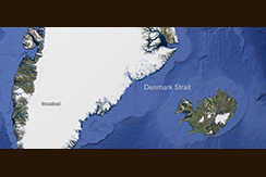
Sunday, 7/9/23, Denmark Strait, en route to Prins Christian Sund, Greenland
-
Latitude: 61.47° Longitude: -33.81°
-
The day at sea was spent crossing the waters of the Denmark Strait. Long ago, during the Viking era, Norsemen and women sailed the same part of the ocean. Eric the Red paved the way for a Norse settlement in southeast Greenland, naming the land in an adequate manner after spending approximately four months searching for the perfect spot. Greenland is indeed green in certain areas, and Seabourn Venture was bound on a similar quest to explore the same land that Eric The Red and the early settlers once called home.
-
During the sea day together, we listened to Conversations in the Discovery Centre from Jon Sigurdsson about Greenland and its peoples, the evolution of the kayak by Rob Egelstaff, and stories about the Vikings by Seb Coulthard. These Conversations enriched our experiences and share knowledge to help explore and interpret these remote regions of the world.
-
Days at sea also serve as a time to relax and disconnect from the outside world. These are contemplative days. It's truely being on holiday.
-
Greenland is an island country in North America and part of the Kingdom of Denmark. It lies between the Arctic and Atlantic oceans, east of the Canadian Arctic Archipelago. Greenland is the world's largest island. It is one of three countries that form the Kingdom of Denmark, the others being Denmark and the Faroe Islands; the citizens of all these countries are citizens of Denmark and of the European Union. The capital of Greenland is Nuuk.
-
Though a part of the continent of North America, Greenland has been politically and culturally associated with Europe (specifically Norway and Denmark, the colonial powers) for more than a millennium, beginning in 986. Greenland has been inhabited at intervals over at least the last 4,500 years by Arctic peoples whose forebears migrated there from what is now Canada. Norsemen settled the uninhabited southern part of Greenland beginning in the 10th century, having previously settled Iceland. Inuit arrived in the 13th century. Though under continuous influence of Norway and Norwegians, Greenland was not formally under the Norwegian crown until 1261. The Norse colonies disappeared in the late 15th century, after Norway was hit by the Black Death and entered a severe decline.
-
In the early 17th century, Dano-Norwegian explorers reached Greenland again. When Denmark and Norway separated Greenland became Danish in 1814 and was fully integrated in the Danish state in 1953 under the Constitution of Denmark, which made the people in Greenland citizens of Denmark. In 1979, Denmark granted home rule to Greenland; in 2008, Greenlanders voted for the Self-Government Act, which transferred more power from the Danish government to the local Greenlandic government. Under the new structure, Greenland has gradually assumed responsibility for a number of governmental services and areas of competence. The Danish government retains control of citizenship, monetary policy, and foreign affairs, including defense. Most residents of Greenland are Inuit. The population is concentrated mainly on the southwest coast, and the rest of the island is sparsely populated. Three-quarters of Greenland is covered by the only permanent ice sheet outside Antarctica. With a population of 56,081, Greenland is the least densely populated region in the world. 67% of its electricity production comes from renewable energy, mostly from hydropower.
- Return to Table of Contents
|
My Photos, Prins Christian Sund
|
-
Wednesday, 7/10/23, Prins Christian Sund, Greenland
-
Latitude: 60.11° Longitude: -43.37°
-
The morning dawned with low temperatures and light winds, a perfect recipe for sea fog in North Atlantic waters. But as Seabourn Venture made its way towards the eastern entrance of Prins Christian Sund, the first patches of blue sky could be spotted, promising better visibility when the sun had time to burn the fog away. And we were not disappointed. By 9:00 am, we could see a horizon and beyond, the first glimpse of the steep mountains of East Greenland, still covered in mist.
-
Seabourn Venture had reached the continental rise, a region where upwelling nutrient-rich waters provide excellent feeding grounds. The Expedition Team crewed all stations, and the outer decks were well-visited to spot wildlife. It wasn't long before sperm whales were sighted, logging (resting) at the water's surface. Sperm whales are the largest of the toothed whales and the largest living carnivore. Lying peacefully at the surface, they presented their stumpy triangular dorsal fins and massive heads. Every now and then, we could see their diagnostic shallow blow projecting forward and to the left. The Bridge officers skillfully manoeuvred Seabourn Venture to allow guests a better view. After a while, the whales were ready for another dive, their broad, triangular flukes went up, and they dived down on the hunt for giant squid living in the deep waters off the Greenlandic coast. Sperm whales are known for their long, deep dives, each of up to one hour. We drew our attention towards new representatives of the avifauna, such as the Sooty Shearwaters and Great Shearwaters that were sitting on the water or flying around the ship.
-
Sailing towards Prins Christian Sund, Seabourn Venture encountered the first ice of the voyage. At first, there were small pieces of brash ice, but finally, greater sea ice floes. The sun had the upper hand over the fog and the clouds, and everyone was on deck to enjoy the view. Tracks on the ice floes and the remains of a seal clearly indicated the presence of the top predator in these parts, a polar bear. Still, even the keen eyes of our polar bear guards could not spot the king of the Arctic.
-
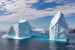
The ship steadily made its way towards the coast and reached the entry of Prins Christian Sund around noon. A huge iceberg in the vicinity was reason enough to change course for a while, and the Bridge officers brought Seabourn Venture close to it for a circumnavigation. Seeing such an iceberg from close up was a special treat and, though interfering with lunch, was a pleasure in itself. Seeing the towering peaks of the iceberg up close was incredible.
-
In the afternoon, Seabourn Venture stopped at Sermeq Kujalleq, the southernmost outlet glacier connected to Greenland's ice sheet. A Zodiac cruise around the ice in this stunning fjord was the undisputed highlight of the day. Towering cliffs of granite, crisscrossed by magmatic intrusions more than 1 billion years in age, tell a geological story from when life on Earth was nothing more than a bacterial film on bare rocks. Contemporary wildlife was present in the form of a bearded seal and legions of mosquitoes. But these bloodsucking little insects could not spoil the fun of cruising through a stunning landscape sculptured by glaciers and mesmerising everybody with its natural beauty. A little sip of champagne in the afternoon sun on the Zodiac left nothing more to be desired, and by 7:00 pm, Seabourn Venture set sail towards its next destination on the west coast of Greenland.
-
During dinner, all venues resonated with lively conversations about the great experience of the day. All the while, Seabourn Venture made its way through the Sund beside dramatic mountain ranges and picturesque scenes of natural beauty. Many of us spent long hours on the outer decks or in the Constellation Lounge, enjoying the views.
- Return to Table of Contents
|
My Photos, Hvalsey and Uunartoq, Greenland
|
-
Thursday, 7/11/23, Hvalsey and Uunartoq, Greenland
-
Latitude: 60.51° Longitude: -45.31°
-
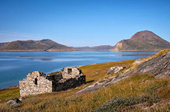
After cruising out of Prins Christian Sund overnight, Seabourn Venture visited the UNESCO World Heritage Site, Hvalsey. Arguably one of the most important Viking sites, it is the largest Greenlandic Viking site and is well preserved. Initially settled in the late 10th century, the 'eastern settlement' survived for 400+ years, with the last recorded event being a wedding on the 14th of September 1408. As guests explored, picturing what life must have been like during that era, they were treated to excellent views of the surrounding mountains.
-
In the afternoon, Seabourn Venture cruised to a relatively hidden spot, Uunartoq. Here, some guests decided to take a humbling Zodiac cruise which battled the fog that rolled in and out. They were rewarded with stunning views of the icebergs that decorated the fjord's deep blue waters.
-
When the Expedition Team landed ashore, they were met with the sight of some locals soaking in the hot baths. Guests heading to shore were graciously invited to join in the fun! Those who enjoyed a plunge in the 36-degree Celsius baths were treated to beautiful flowers in the surrounding landscape while looking at icebergs in the distance. Not exactly your typical day in Greenland!
- Return to Table of Contents
|
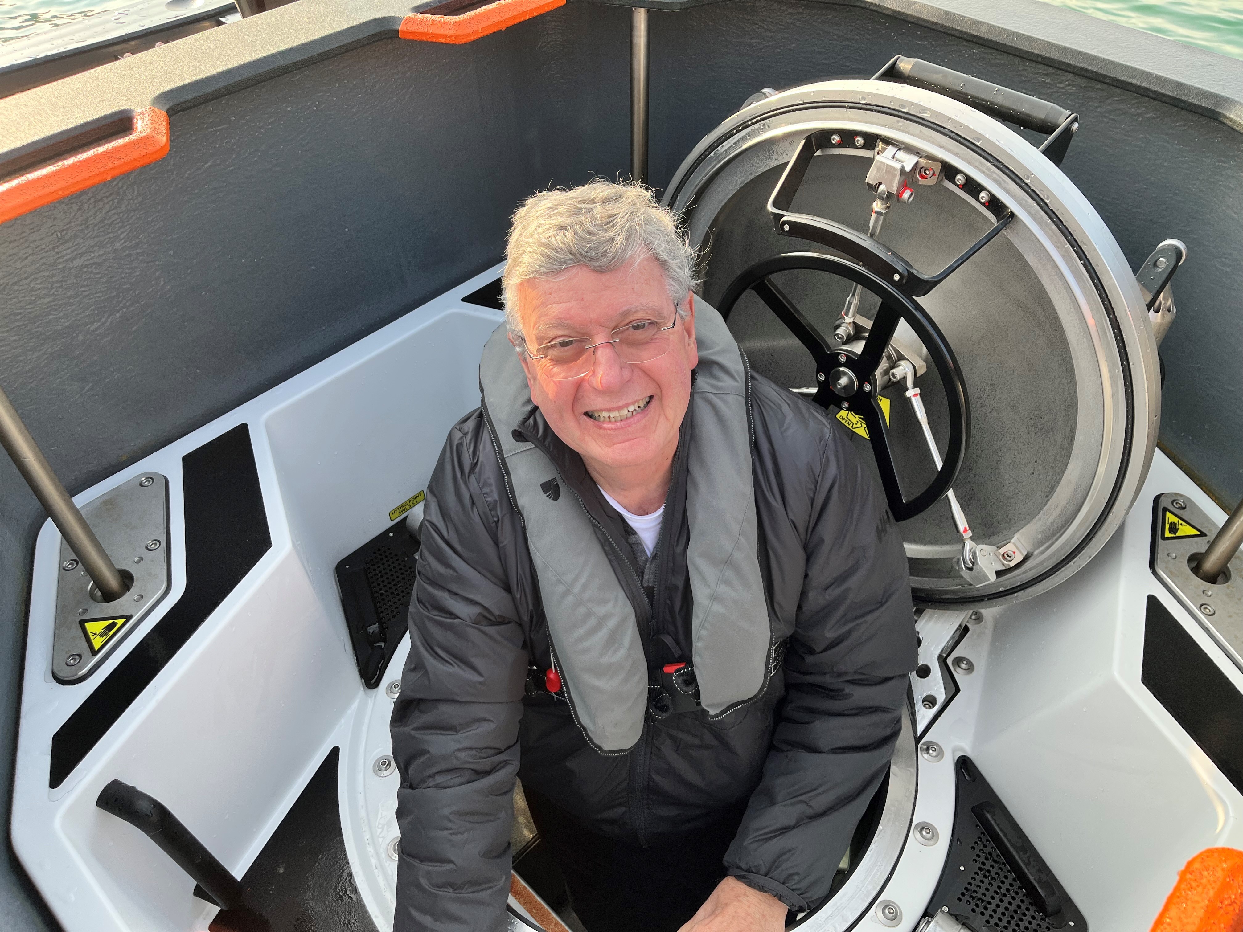
My Photos of my Submersible Dive
My Videos of my Submersible Dive
Ross Hoff's Photos of
my Submersible Dive
Photos of Kangerluq Fjord
Zodiac Exploration
|
-
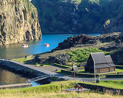
Wednessday, 7/12/23, Aappilattoq & Kangerluq Fjord, Greenland
-
Latitude: 60.18° Longitude: -43.63°
-
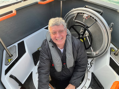
Aappilattoq, Greenland is also the site of my dive in the submersible. Six of us joined our pilot, Merel Dalebout for a dive down to 791 feet. The original plan was to go down about half as far and find the wall of the fjord. The sonar was giving weird returns, so she decided it was easier to find the bottom than the wall in the allotted time. The operation was very professional and very educational. It was the highlight of my cruise.
-
Greenland's coast has five major cities and numerous little towns in the more remote parts of the country. Today, Seabourn Venture visited one of the most southerly and remote little villages in the vastness of Greenland, Appiattoq, population: 53 souls.
-
At first impression, as Seabourn Venture came to anchor below towering mountains surrounded by icebergs and brash ice, this tiny little village is hidden out of sight by rocky bluffs and moss-covered glacial erratic stones. Hidden to one side of the impressive scenery, there is a small harbour which offers access to a beautiful collection of colourful houses: yellow, red, blue, green, white, and black. Each house is humble in appearance, and the harbour dock is adorned with many fishing boats and the noticeable smell of industrious fishery.
-
Appilattoq is a remote community of hard-working and proud Inuit people living at the edge of a vast sea channel that leads to Prins Christian Sound. Seals are hunted here for their fur and blubber, fish of all kinds are sold in the Royal Greenland fish market, and whale bones adorn the entrances to homes.
-
The submersibles explored the fjord just offshore, venturing to approximately 242 meters depth. The skilled pilots showed us the wonders of the deep: sea stars, sponges, anemones, comb jellies, fish, and urchins. The life beneath the waters of Greenland is rich and yet so unknown to most humans. It is the subject of much scientific interest and future exploration.
-
Meanwhile, the kayak team also had the opportunity to explore the region, heading away from the hustle and bustle of this busy Greenlandic metropolis. The tranquillity of the ice, tinkling in the water, the stiff-winged flight of the Northern Fulmar, the silent soaring of the White-tailed Eagle above.
-
The day ended after a short visit to Kangerluq Fjord, a massive body of ice flowing over the landscape into a deep fjord. The Kangerluq Glacier descends from the interior of the Greenlandic ice cap and, despite its vast size, is much smaller than it was a mere twenty years ago. A few decades ago, the ship would not have been able to visit the same location; the glacier would have occupied the same space as the ship's anchorage. Kangerluq Fjord stands witness to the changes caused by global warming, a gouged landscape scarred and torn by massive glacial forces that are no longer present. Stained with iron ore deposits, broken up by massive volcanic intrusions, carved and polished by glaciers, wind and waves, today, Seabourn Venture visited the past.
- Return to Table of Contents
|
Photos, East Greenland &
the Polar Plunge
Video of the Polar Plunge
|
-
Thursday Afternoon, 7/13/23, Polar Plunge, East Greenland
-
Latitude: 60.35° Longitude: -41.99°
-
For those who have always been interested in adventurous movies ... on this day and for some mysterious reason - one movie seemed to resonate - The Hunt for the Red October starring Sean Connery, Alec Baldwin and Sam Neil. Today, for those with vivid imaginations, a parallel adventure plot appeared to be playing out aboard Seabourn Venture. As the polar-class vessel proceeded north up the east coast of Greenland and wove a path through fragmented chunks of sea ice looking for 'Peanut Butters' (expedition code word for 'Polar Bears'), it became 'The Hunt for the White July'. Like the submarine 'Red October' in the movie, the 'peanut butters' were proving just as elusive. There was, however, the occasional seal lounging on sea ice enjoying the Arctic sunshine, and surely, if the prey (being seal) was around, then so must be the predator. Everyone onboard hoped the ship would be lucky to come across these magnificent beasts.
-
While travelling through the sea ice, we stood on the mooring line viewing platforms extending three to four metres outward from the vessel's bow on both the port (left) and starboard (right) sides of Seabourn Venture. It was an exhilarating feeling standing on this platform, sensing the penetrating chill in the air as the vessel's bow casually pushes aside large quantities of sea ice beneath.
-
In a matter of minutes, the fine sunny weather and visibility to the Greenland coastline were completely gone ... Seabourn Venture was suddenly immersed in fog. Without the land and sun for reference, it was near impossible to know in which direction the ship travelled. Such are the hazards of navigating at high latitudes - where weather conditions can change instantly and become perilous or pleasant.
-
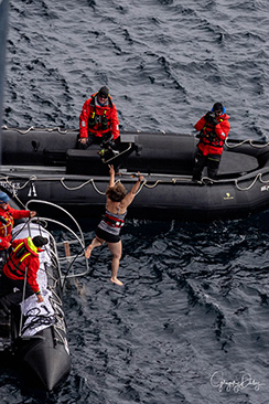
In the afternoon, there was an atmosphere of fun and frivolity at polar plunge time. Guests lined up to throw themselves into the frigid Arctic waters, albeit attached to a safety harness. In the background, and as far as the eye could see, were continuous lines of sea ice, gradually drifting south. It's a crazy experience with a great deal of excitement and laughter sprinkled with bravado and a degree of fear. However, the Expedition Team was on-hand to ensure maximum safety, and the ship's lovely medical team was in attendance just in case. Fortunately, they always have little to do other than to look good. In all his penguin splendour, the Entertainment Director Brian was there, supported by the Hotel Team, to provide liquid comforts and warm towels in the post-plunge aftermath. Of course, photographer Daniel was also conveniently stationed on a Zodiac to capture for posterity the shocked face of the polar plungers as they emerged from the brisk Arctic water.
- Return to Table of Contents
|
Photos of Greenland Sea, Greenland
|
-
Friday, 7/14/23, Polar Bear Hunt - Greenland Sea, Greenland
-
Latitude: 61.98° Longitude: -40.94°
-
There were polar bears out there, but where were they? There are roughly 26,000 polar bears worldwide, and around 60-80% of these are in Canada, so the chances of seeing one in the area Seabourn Venture has been travelling in would appear to be slight, if not non-existent. However, there are polar bears resident in Southeast Greenland, and last year, an important paper was published in the journal Science documenting this particular subpopulation, which is genetically different from any of the other 19 previously described polar bear populations. Beth Shapiro, professor of genetics at the University of California, Santa Cruz, stated "They are the most genetically isolated polar bears anywhere on the planet and they've been separated from other populations for hundreds of years".
-
The reason they are so isolated is that their hunting area is surrounded by mountains, the Greenland ice sheet to the west, the open sea of the Denmark Strait to the east, and the fast-flowing, hazardous East Greenland coastal current offshore. These bears prefer to base themselves in a home fjord, and when they are swept away on ice floes, often 120 miles to the south, they calmly swim ashore and walk back to their home fjord on the mainland.
-
During winter, when the sea freezes, they hunt for seals on the sea ice like all other polar bears. Then for the rest of the year, these polar bears have developed a different strategy to avoid starvation. They hunt seals from freshwater icebergs that have calved from the glaciers at the top of the network of steep-sided fjords that are abundant in this part of Greenland. Kristin Laidre, a polar scientist from Washington's Applied Physics Laboratory, said "... these bears provide a glimpse into how Greenland's bears may survive under future climate scenarios" and "the sea ice conditions in Southeast Greenland today resemble what is predicted for Northeast Greenland later this century".
-
Perhaps there was a lurking polar bear peeking out at Seabourn Venture as the ship cruised through the pack ice of East Greenland this morning, but it couldn't be found. Maybe there was a black nose poking up above the surface of the sea, a polar bear sneaking up on a sleeping seal as the Zodiacs drifted by during the afternoon excursion. These sea mammals are so well adapted to polar conditions, with four inches of blubber and their thick white fur, they lose so little heat that they don't show up on thermal imaging cameras. They are remarkably intelligent and are supposed to put a paw up over their faces to hide their black noses when they are crawling towards targeted seals on the ice. Silent and still, they remained undetected by those onboard Seabourn Venture today.
-
The polar bears in East Greenland are physically smaller than other polar bears and there are some concerns that their isolation and the relatively small numbers of this group may lead to genetic disorders due to inbreeding in the future.
-
The contrast to the protected, privileged lives of everyone onboard the ship is stark, and the polar bears of the Arctic live their lives on the edge. However, all face a big adventure in the future, a journey with an uncertain outcome, on a changing planet. Who knows what the future will bring? Taking everything into account, the polar bear seems to have a more uncertain future than that of humans. Sylvia Earle, the eminent marine biologist, summed this up as follows:
-
"For humans, the Arctic is a harshly inhospitable place, but the conditions there are precisely what polar bears require to survive - and thrive. 'Harsh' to us is 'home' for them. Take away the ice and snow, increase the temperature a little, and the realm that makes their lives possible literally melts away."
- Return to Table of Contents
|
My Photos, Denmark Strait
to Reykjavik, Icelands
& Ship's Bridge Tour
|
-
Saturday, 7/15/23, Denmark Strait, en route to Reykjavik, Iceland
-
Latitude: 63.48° Longitude: -28.15°
-
The ship awoke to calm seas and clear skies on the final day of an incredible voyage. As Seabourn Venture headed back across the Denmark Strait to Reykjavik, we reflected on the last couple of weeks, took in some entertainment and started Packing.
-
During the morning, there were two Conversations in the Discovery Centre. The first, by the ship's Safety and Environmental Officers, provided information on how Seabourn Venture functions behind the scenes. In the second, Dr Toby Musgrave talked about the history of naturalist and botanist Joseph Banks.
-
The calm seas gave the impression of sailing on a lake. The Expedition Team were on watch around the ship looking for marine life, and those who were patient enough had sightings of dolphins, sei whales and pilot whales.
-
The afternoon started with a final Conversation with Dr Beth Healey. Meanwhile, the Bridge opened its doors again to allow us to learn how the ship is controlled and navigation challenges in polar regions. Following this, we joined the Expedition Team for an entertaining recap by Daniel Fox, showcasing some of his best photos from the Arctic polar plunge.
-
As the day started to wind down and the wind and waves picked up, the evening's entertainment commenced. We were invited to the Patio for the Epicurean event, serving seafood and cheeses and, of course, the bar was on hand with cocktails.
-
Before enjoying their last dinner and drinks of the voyage and settling in to rest before their long day of travel, we were invited to the Discovery Centre to view the incredible video put together by John. Shedwick. Showcasing the best of each day, from the waterfalls and volcanoes of Iceland to the glaciers and sea ice of Greenland, this mesmerizing video bought back all the emotions of the last two weeks.
- Return to Table of Contents
|
Photos, Disembarking
& Volcano Litli Hrútur
|
-
Sunday, 7/16/23, Reykjavik, Iceland
-
Latitude: 64.15° Longitude: -21.86°
-
Seabourn Venture arrived early in Reykjavik this morning. It was cloudy, but there was still nice weather to welcome the ship; no rain or strong winds.
-
Unfortunately, today marked the end of the voyage, with most of us disembarking the ship. They planned to either stay for a few days in the capital of Iceland or else fly home directly. I chose to fly home directly.
-
Seabourn Venture had just finished a circumnavigation of Iceland and a voyage across the Denmark Strait to East Greenland. Iceland and Greenland are unique countries to visit, with remarkable cultures and the remains of ancient Norse settlements. These countries have beautiful, colourful landscapes with glaciers, fjords, and gorgeous waterfalls.
-
I was allowed to offload early as my flight was a tight connection.
-
The Icelandic Meteorological Office (IMO) said the “minor” eruption of a volcano began Monday in Iceland’s Reykjanes Peninsula but no ash has been emitted and so far no disruption has been reported at the country’s Keflavik Airport.
-
The IMO said there was a 200-meter (656 feet) long fissure on the slopes of the Litli Hrútur mountain, “from which lava is emerging as a series of fountains.” Photos show streams of lava flowing along the dark fields, with small fires in the distance and thick smoke billowing in the air.
-
Since the eruption took place in an uninhabited area, there were no “immediate risks” to communities or infrastructure, the IMO said – but it warned people not to venture near the area, saying there will be an accumulation of “dangerously high levels of volcanic gases.”
- Return to Table of Contents
|

Photos of The LONG &
Ridiculous Flight Home
|
-
Sunday & Monday, 7/16 & 17/23, The LONG, Ridiculous Flight Home
-
The plan - depart Iceland 11am Sunday, arrive home 9:30pm Sunday due to time zone changes.
-
Delta's execution, on time departure, 12 hours late including an overnight in the Atlanta airport.
-
The flight from Iceland to JFK was wonderful. No problems at all, on time departure and arrival.
-
The problems began at JFK. The first officer lived in Florida and had to fly in to make this flight. He was delayed by weather. Two hour delay ate into my 2.5 hour layover in Atlanta, but it was still doable. I boarded and found an out- of order sign on my seat. (The seat would not recline, which would nopt have bothered me on the short flight to Atlanta, but no, it's illegal to sit in a non-reclining seat. Wonder which FAR is that one!) I was already aggravated plenty but then I had to argue about flying to Atlanta on this flight. With Diamond priveleges and Fist Class ticket, I finally prevailed.
-
We landed Atlanta with 20 minutes for my connection. They knew I was coming. I'm Diamond First Class so I shouldn't worry, right? Wrong! I arrived at the gate two minutes early, and although the airplane door was still open, the gate door was closed and I was not allowed on. So now I'm furious.
-
To add insult to injury, Delta denied me a hotel room saying the flight was ATC delayed (which it was not, it was weather) and I spent the night at a gate on a bench in Atlanta terminal. So what's the point of being loyal to an airline when they treat you this wway?
-
I made it home Monday morning, picked up my dog, Kali, and slept for most of the rest of the day, tired and exhausted.
-
It was a wonderful trip, a dream of a lifetime. It's a shame Delta had to end it so poorly for me. Shame on you, Delta Airlines!
- Return to Table of Contents
|